Gascoyne Project
HIGH GRADE HISTORICAL WORKINGS FOR BASE AND PRECIOUS METALS
Highlights
- Taruga has applied for three contiguous permits (covering 385km2) in the highly prospective northern Gascoyne province, which contain numerous high grade historical workings for base and precious metals1
- Taruga has executed an option agreement to acquire 100% of granted tenement E08/3245 (“Thowagee”) (ASX Announcement 20/11/2024).
- Thowagee is contiguous with Taruga’s current Gascoyne applications, and features two historic polymetallic mining operations from outcropping hydrothermal veins (Thowagee Mine and Thowagee Bore).
- Historic mining at Thowagee Mine produced 15.2 tonnes of lead and 5,878 grams of silver from concentrate produced on site, with gold, copper and zinc also present in the mineral system.
- Historical Rock chip results include:
- TH12 – 39g/t Au, 88 g/t Ag, 15.5% Pb and 4.35% Cu
- TH16 – 6g/t Au, 134 g/t Ag, 30.3% Pb
- TH 8 – 55g/t Au, 19.5% Cu
- TH9 – 286g/t Ag, 59.3% Pb
- TH25 – 86g/t Ag, 22.1% Pb, 3.95% Zn
- Uaroo-Hill – Production of lead concentrate from outcropping mineralisation – 19.59 tonnes were reportedly mined in 1956 at a grade of 7% Pb and 301 g/t Silver, with gold and copper reported to also be present in concentrate.2
- Donelly Kooline (Emu) – Production of lead concentrate from outcropping mineralisation – 4.52 tonnes were reportedly mined in 1952 at an average grade of 8% Pb and 129 g/t silver, with gold and copper reported to also be present in concentrate.3
- E08/3734 (“Uaroo East project”) also features three historic copper workings in the NE of the permit called Moodong Well, and several outcropping pegmatoids which may be prospective for Lithium and REE.4
Project overview
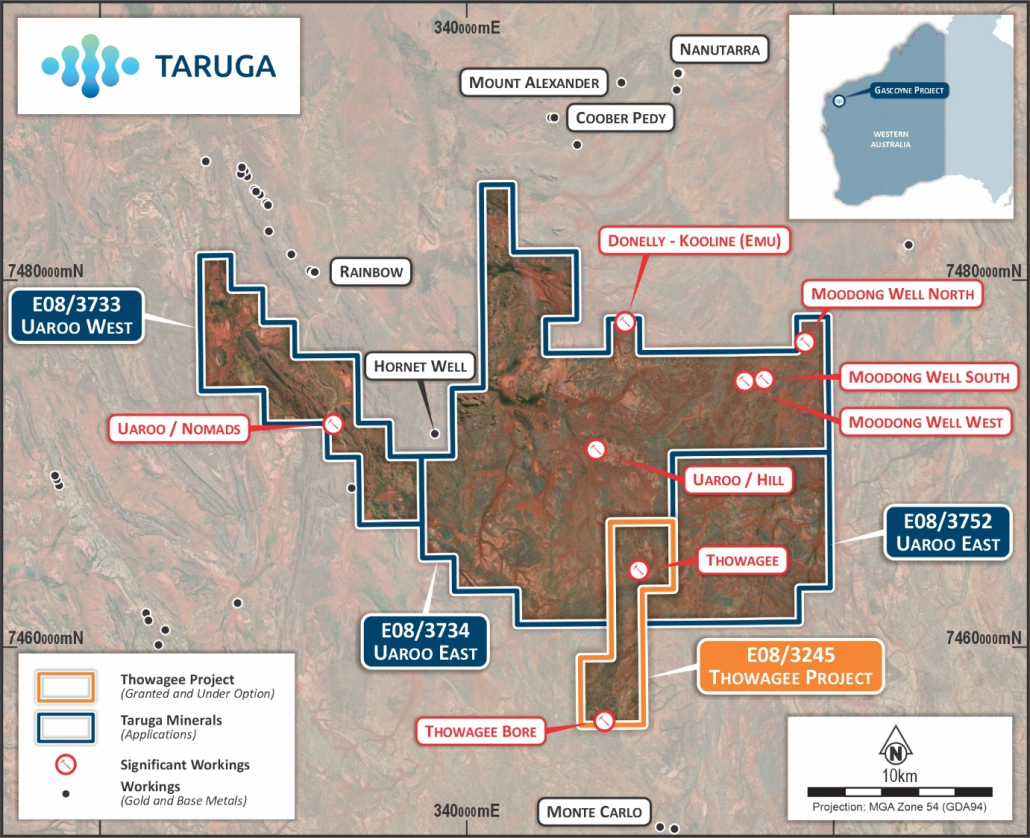
Taruga has secured three applications in the northern Gascoyne province, an area rich with historic workings and mining (Figure 1), but also a significant lack of exploration efforts since the 1980’s. Historical exploration had a focus on base and precious metals (but no drilling), iron ore and uranium.
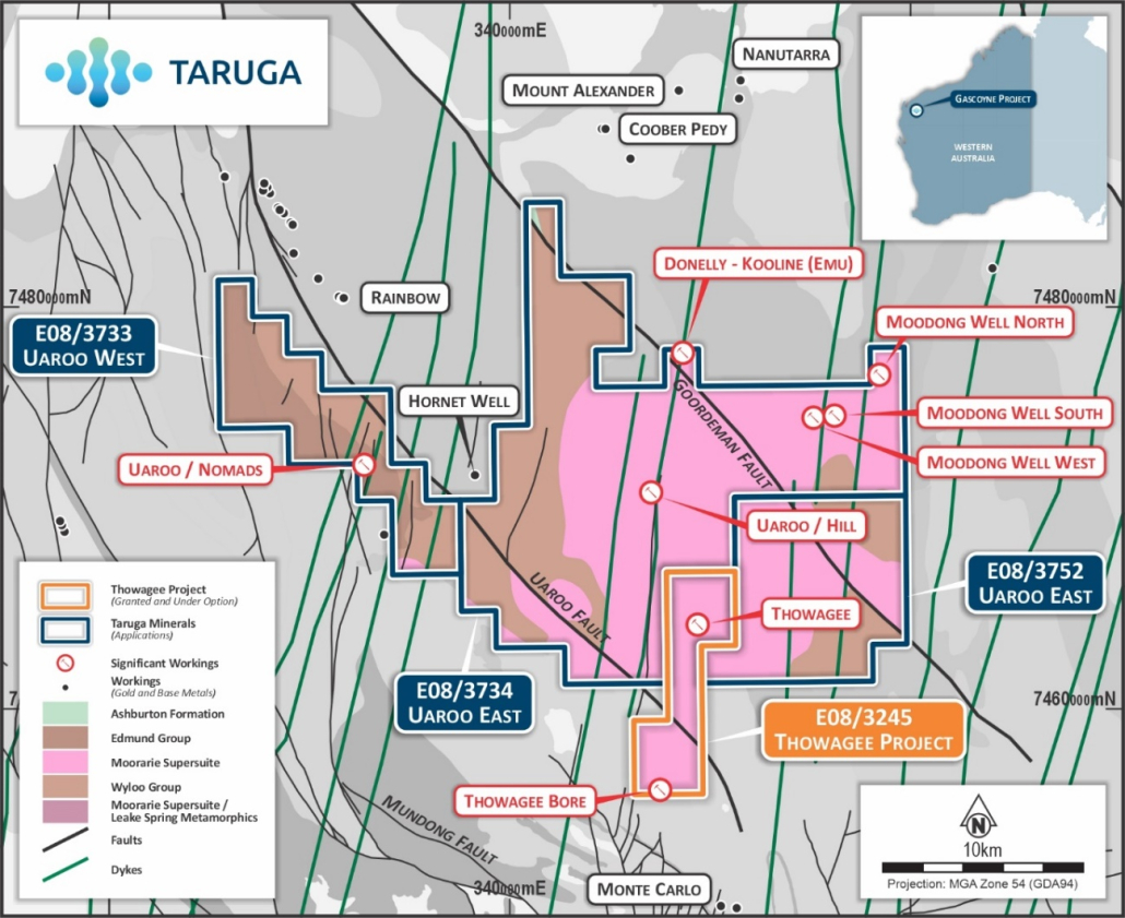
The permit areas have favourable geology, with the important presence of the Leake Springs Metamorphics (previously called the Morrisey Metamorphics), which are also present in the Dreadnought Resources ltd (DRE) tenure further south. The majority of the workings sit in and near the significant structures of the Goordeman and Uaroo Faults (which run NW-SE through the permits) (Figure 2), with the late mafic dykes (N-S trending) likely to provide conduits for fluid movement and possible traps for mineralisation.
Of particular interest to Taruga is the 1km structural corridor that exists between the high – grade polymetallic mines of Donelly Kooline and Uaroo/Hill, within Uaroo East project. This corridor is part of a larger high-grade trend of polymetallic mineralisation, which spans 5km from Mount Alexander to the North and finishing at the Monte Carlo deposit to the South. Many of these workings sit within or near N-S trending dolerite (mafic) dykes (Figure 2).
Historic records indicate that the majority of the mines/workings have been classified as hydrothermal vein/shear hosted deposits, although Mount Alexander (Figure 1) is listed as a strataform base metal deposit with numerous outcropping gossans. Further exploration at Mount Alexander (inc RC drilling) postulated the likelihood of sulphides having remobilised into skarns/veins at surface. This type of polymetallic mineral assemblage is also common among VMS deposits, and, given the possible remobilisation of sulphides at Mount Alexander, the geological model that applies to the workings within the Taruga permit areas requires further investigation.
Table: Tenement details
| Tenement | Holder* | Application / Grant Date | Area (blocks) | Area (km2) |
| E08/3245 | Western Silver Pty Ltd | 12/01/2023 | 10 | 31.5 |
| E08/3733 | 460 Resources Pty Ltd | 15/07/2024 | 20 | 63 |
| E08/3734 | 460 Resources Pty Ltd | 16/07/2024 | 77 | 243 |
| E08/3752 | 460 Resources Pty Ltd | 14/10/2024 | 25 | 79 |
*460 Resources Pty Ltd is a wholly-owned subsidiary of the Company
Geology
The Uaroo project areas sit within the northern portion of the Gascoyne province, a complex set of folded, faulted, metamorphosed and later intruded set of rocks. The Uaroo West project includes Edmund Group (formerly Uaroo Group) sedimentary rocks and Ashburton Formation (Wyloo Group rocks) with North-South trending cross cutting mafic dykes. Whilst the Uaroo East project includes Wyloo Group rocks, Leake Springs Metamorphics and Moorarie Supersuite granites, also with North-South mafic dykes.
It is noted that the Leake Springs Metamorphics are usually strongly magnetic and layered and not easily distinguishable from the Wyloo Group rocks, which correlates with mapping and reference to the Morrissey Metamorphics (now known as Leake Springs Metamorphics). The sediment cover in this area may have limited the outcrop and so requires further field investigation into the grade of metamorphism and rocks present.
Rico Resources (subsidiary of Talisman Mining) noted that the area is predominantly underlain by Paleoproterozoic pelitic and psammitic phyllite and schist, calc-silicate rock and minor amphibolite assigned to the Lower to Middle Proterozoic Leake Springs Metamorphics of the Gascoyne Province. The Leake Springs Metamorphics are locally intruded by foliated and gneissic granite of the Moorarie Supersuite. Both units are unconformably overlain by the Paleoproterozoic to Mesoproterozoic Uaroo Group (Edmund Group), which consists of sandstone, siltstone, mudstone, banded iron formation, dolostone, and chert with minor conglomerate. Structurally two significant faults the Uaroo and the Goordeman Fault cross the licence area running South-East to North-West whilst centrally the main folding is a North-NorthWest to South-SouthEast syncline.
Next Steps
Taruga is planning initial field reconnaissance to review the Thowagee workings. An initial work plan includes sampling the mineralisation and rock types present to verify reported grades and map the structural trends in correlation with available geophysical data. Available data sets include radiometrics, magnetics, mapped outcrop geology and interpreted bedrock maps. The next steps beyond the initial Thowagee mine focus include implementing field programs to rock chip gossans and their location and extent which is only been noted in historical reporting without further details. Other follow up work will include using geophysical datasets and in field mapping to trace out the host shear extents and mineralisation potential.
The field observations and verified historical data, including from neighbouring workings/mines, are to be incorporated and interrogated as part of a broader review of the applicable geological models for potential mineralisation events.
References
- Uaroo/Nomads, MINEDEX Site Code S0017747 (https://minedex.dmirs.wa.gov.au/Web/sites/details/35478c77-07ee-49f0-9884-a8ef010ccbe1)
- Uaroo/Hill, MINEDEX Site Code S0017744 (https://minedex.dmirs.wa.gov.au/Web/sites/details/F5E9F782-4AC2-4120-93B2-D60CB1FAB28C)
- Donelly-Kooline, MINEDEX Site Code S0017699 (https://minedex.dmirs.wa.gov.au/Web/sites/details/79A6E15D-2891-4C95-BF5C-2F8F6DE2B587)
- AFMECO Pty Ltd Gascoyne Bangemall Area Annual Report, 1975: WAMEX Report A5838
Figure 1: Location and tenement map displaying historic workings and mines within and around Taruga applications.
Figure 2: Local geology (GSWA 500K interpreted basement) and workings.
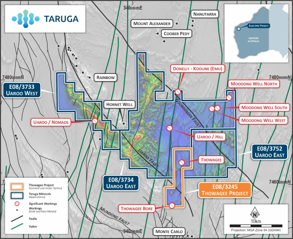
Figure 3: Magnetics (TMI) noting significant faults (NW/SE) and intrusive dykes (N/S)


