FLINDERS IOCG PROJECT – TAR 100%
HIGH GRADE IRON-OXIDE-COPPER-GOLD (IOCG) PROJECT
Highlights
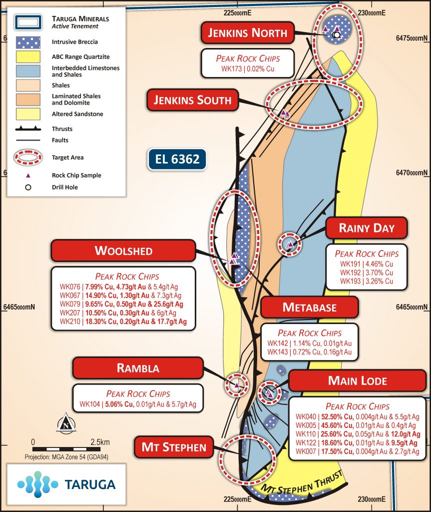
- The Flinders Project is highly prospective for IOCG mineralisation with high-grade copper and gold sample results from outcropping mineralised breccias over a strike of 6.4km
- Further strike potential of up to 15km identified by reprocessing and modelling of government magnetics, extending into the Torrens IOCG project
- The geochemical signature and large geophysical anomalies underlying high-grade mineralised breccias indicates potential for a large IOCG system
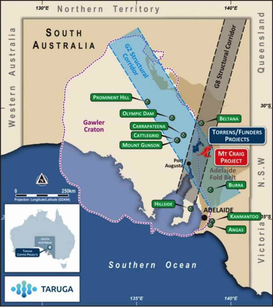
- The Flinders Project lies at the intersection of two regional structural corridors which host the Olympic Dam and Carrapateena IOCG’s (NW trending) and Beltana Zinc and Leigh Creek Copper (NE trending), and sits only 80km from Carrapateena and 150km from Olympic Dam
- Significant upside potential with limited modern exploration and multiple high-grade targets
Project overview
The Flinders Project hosts a highly prospective copper-gold target portfolio, in the same structural setting as the giant Olympic Dam (10 billion tonnes @ 0.82% Cu, 0.31g/t Au and 260ppm U3O8) and Carrapateena (760Mt @ 0.8% Cu and 0.3g/t Au and 143ppm U3O8) deposits. The project contains significant outcropping, high grade Cu-Au surface mineralisation in iron rich breccias, which was the focus of historical mining in the 1800’s. Flinders Project is located 80km from Carrapateena and 150km from Olympic Dam, with power and rail on the lease.
Flinders Project Prospects
- Woolshed – Mineralised breccia with high-grade copper, gold and silver mineralisation associated with a 3km x 1.6km linear magnetic anomaly.
- Main Lode – Mineralised breccia with a history of high-grade copper mining – significant copper and cobalt mineralisation with anomalous gold and silver identified.
- Jenkins North – A large 2.6 x 1.2 km magnetic anomaly known to contain mineralised breccias similar to the Woolshed breccia which hosts high-grade copper and gold
- Jenkins South – A large 3.6 x 1.2km magnetic anomaly adjacent the Jenkins North Anomaly with similar features to Jenkins North
- Mt Stephen – A 1.6 x 1km magnetic anomaly associated with the flexture point of the Mt Stephen’s Thrust which hosts Woolshed copper-gold mineralisation further north
- Rainy Day – Mineralised breccia with an unrecorded artisanal copper mining history and rock-chip results pending
- Rambla – Sediment hosted, with high-grade copper and silver mineralisation associated with a 1.8km striking white-rock alteration feature
Project History
Various artisanal and small-scale copper mining operations occurred within the Warrakimbo Ranges where high-grade copper mineralisation was first noted in the late 1800’s and continued intermittently for 130 years.
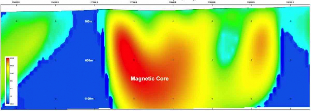
Historical exploration failed to recognise the potential connectivity between the outcropping mineralisation in the region and the IOCG affinity of the geochemistry and mineral assemblage. Only 1 shallow hole has been sunk into Main Lode which intersected mineralised breccia at depth however was never assayed nor followed up. Two shallow holes drilled into the Jenkins North magnetic anomaly intersected hematite and magnetite altered volcanic breccia resembling the Woolshed breccia which hosts high-grade copper and gold at surface. Geophysical modelling indicates the historical drilling fell short of reaching the magnetic source which extends to over a kilometre depth from 4 meters, as a pipe-like feature.
Exploration Plan – Flinders Project IOCG Targets
- Detailed rock-chip, streams and soils geochemistry and mapping (complete)
- Reprocessing of government geophysics data (complete)
- High-resolution gravity survey to identify hematite-IOCG targets like Main Lode and Rainy Day prospects (complete)
- High resolution airborne magnetics to infill government data (2022)
- Drill testing of priority IOCG targets at Woolshed and Jenkins (pending Ministerial authorisations under the Aboriginal Heritage Act)
Prospects
Woolshed/Metabase
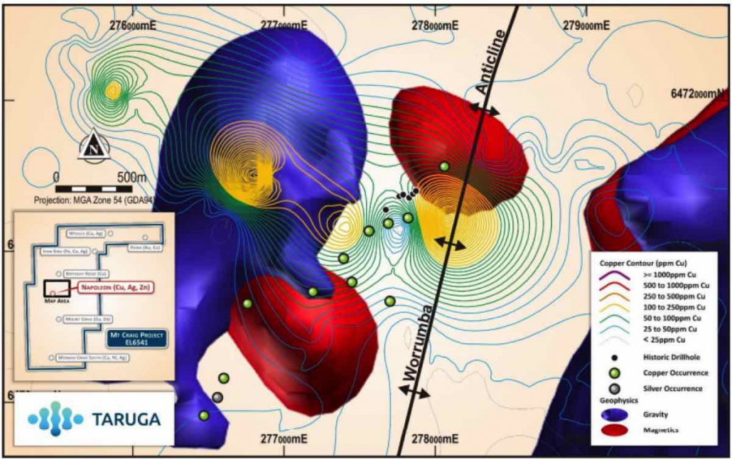
At Woolshed/Metabase, a rich copper geochemical anomaly has been defined for over 3km’s along the Mt Stephen Thrust (MST) and is associated with a prominent magnetic high and gravity anomaly. A gravity body is modelled to extend from near-surface to a depth of 700m, which has low level copper in soil anomalism and adjoins the magnetic body and zone of high-copper anomalism immediately to the east, as shown in Figure 3. Thirty RC holes for approximately 4,000m has been planned consisting of 6 drill fences covering 2,000m along strike and 500m across strike over the Woolshed target.
Jenkins North and Jenkins South
Jenkins North (Figure 4) and Jenkins South (Figure 5) are characterised by large coincident and semi-coincident gravity and magnetic anomalies which have overlying copper-rich hematite and magnetite breccias in outcrop. Only 2 shallow holes have been drilled historically at Jenkins north, which failed to intersect the magnetic target, however intersected hematite-altered volcanic brecccias which resemble those which host high-grade copper and gold mineralisation along strike south at Woolshed.
Main Lode
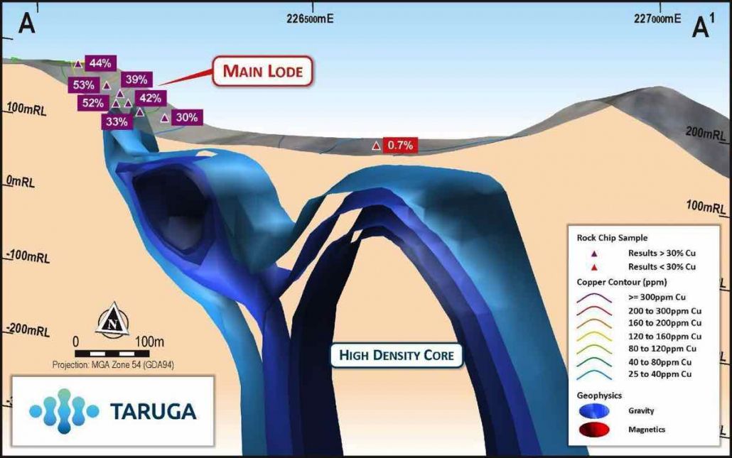
Copper and hematite hosted in hydrothermal iron breccias were mined historically at Main Lode from surface down to roughly 30m below surface. A gravity completed by Taruga over the Main Lode historical workings defined a weak gravity anomaly coincident with the area of mining, along with a significant gravity anomaly down-dip from the workings as shown in section in Figure 6. This indicates the potential for the mineralised breccias to blow-out down-dip into a larger mineralised zone.
Grab samples from mining spoils at Main Lode reported exceptionally high copper grades of up to 52% Cu and 14g/t Ag. All indications are that Main Lode has the potential to develop into a significant mineralised system down-dip at depth.
Mt Stephen Thrust/Mt Stephen Prospect
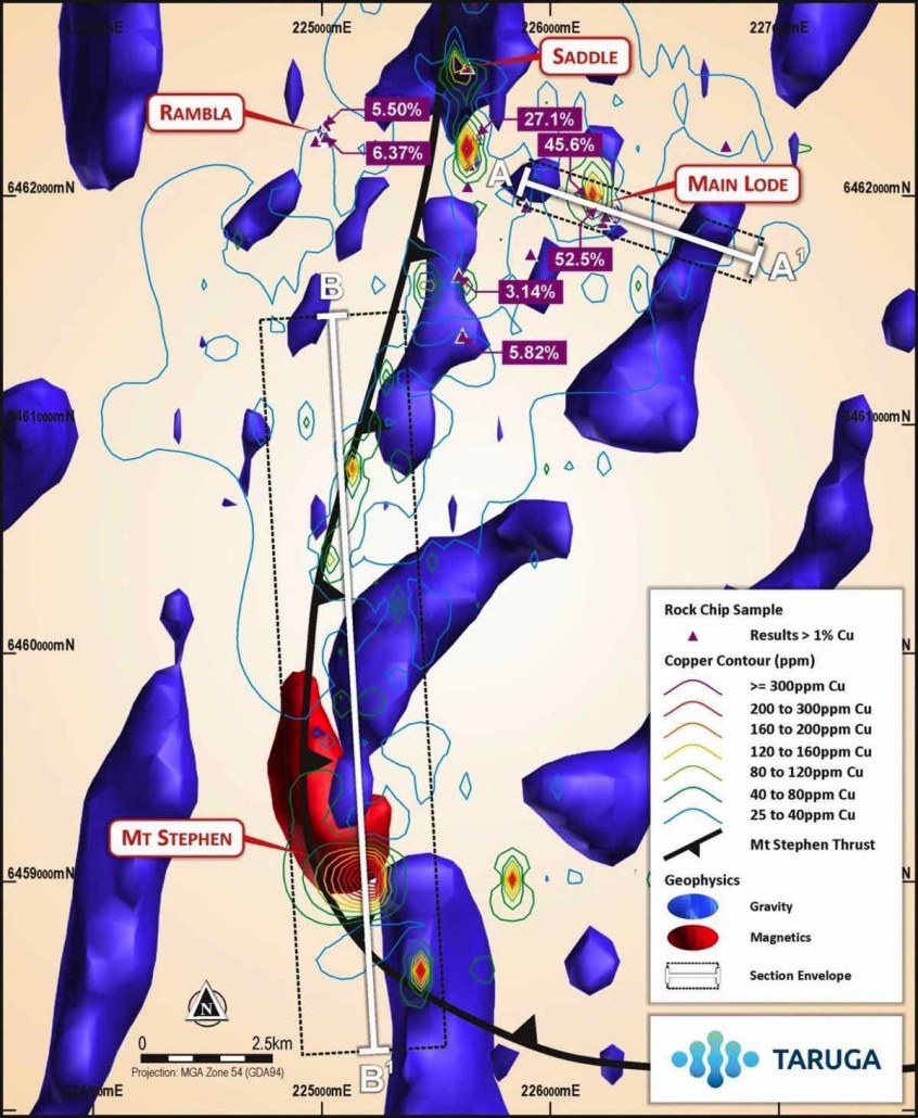
A continuous copper in soil anomaly supported by the geophysics has been defined over more than 10km along the Mt Stephen Thrust from Woolshed/Metabase in the north and the Mt Stephen Prospect in the south. It is highly likely that areas of increased anomalism are associated with cross-cutting structures with increased hydrothermal fluid flow. A new exposure, the Saddle Prospect (Saddle), was identified over an area of 650m x 30m along the MST and a further 700m along an adjoining splay structure for a combined strike length of >1,300m as shown in Figure 7. Highly significant results of 27.1% Cu and 9.2g/t Ag (WK0602) and 6.3% Cu and 3.8g/t Ag (WK0599) were reported from the northern portion of Saddle and 5.8% Cu (WK0619) and 3.1% Cu (WK0606) were reported from the southern splay structure.
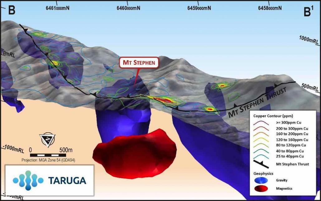
The Mt Stephen Prospect lies within the crush zone at the flexure of the MST and has a strong, coincident magnetic and gravity anomaly with soil support at surface as shown in Figures 7 and 8. The entire structure is anomalous in copper over 3.5km up to the outcropping, mineralised breccia and sandstone/siltstones identified along the MST (Saddle Prospect). The coincident magnetics, gravity and associated geochemical anomalies makes the Mt Stephen Prospect a prime target for future exploration.
Rambla Prospect
Spoils from a single shaft at Rambla showed good copper mineralisation hosted within sediments with little iron association, which is typical of Zambian style sedimentary hosted mineralisation. Rambla mineralisation is associated with a low order copper in soil anomaly shown in Figure 3 which extends over 1.5km in a north-east direction. Rambla lies to the west of the MST and supports a different style of mineralisation at Flinders which will be drill tested.
Figure 1: Regional Map showing the project locations within the Adelaide Geosyncline and G2 Structural Corridor within the Gawler Craton and Significant Mines/Deposits Nearby
Figure 2: Detailed Geology Map for the Flinders Project Target Area showing Prospects, Rock Chip Sample Results, Breccias and Historic Drillhole Locations
Figure 3: Woolshed/Metabase Geophysical Map showing the Modelled Magnetic Core and Prominent Gravity Anomalies, Cu in Soil Contours, and Rock Chip and Soil Highlights.
Figure 4. Cross section of Jenkins North modelled magnetic core showing historical drilling.
Figure 5. Cross section of Jenkins South modelled magnetic core.
Figure 6: Oblique section across Main Lode historical workings showing the surface rock-chip highlights, soil geochemical anomaly contours and a large dense gravity anomaly modelled to extend downdip form the historical mine.
Figure 7: Copper in Soil Contours along the Interpreted MST showing Prospect Locations, Gravity and Magnetic Anomalies and Gravity Section Lines
Figure 8: An Oblique Section Across the Mt Stephen Prospect showing Copper in Soil Contours, the MST and the Coincident Gravity and Magnetic Anomalies.
